Pemberton
& Warren National Park.
Distance from Perth: 330km
Nearest Fuel: Pemberton
Size: over 3000 hectares of Karri forest (Warren National Park) Time to allow: 3 days+, perfect for long weekends or a week long holiday.
The town mainly thrives on tourists, there is plenty of accommodation in and around the outskirts of town.
As in a lot of the South West of WA there are many wineries and a few micro breweries around that are well worth a visit, along with great restaurants (quite a few at the wineries).
Pemberton visitors centre has loads of information on the area and is really a must visit in this area. They also have free maps locating all places of interest.
Pemberton history:

In the late 1800s and early 1900s the timber industry really took off and three timber mills were operating in the Pemberton area, from these mills the town Pemberton was established and grew.
Most of the milling in those days was done by hand, this would have been intensive labour.
The mills used trains to transport the timber and as you explore the surrounds of Pemberton and national parks you will come across some old rail tracks with overgrown vegetation hiding the rest of it. Even in the heart of Pemberton there is an old rail track running through town. Part of this rail is now used as a tourist train ride.
Gloucester National Park:
Gloucester National Park is at the door step of Pemberton.
The Gloucester Tree and The Cascades are the main attractions in the park, (for Gloucester Tree see Climbing Giant Trees).
In dense Karri forest south of the Gloucester Tree, the Lefroy Brook runs over rock shelves creating "The Cascades"
In summer you should still get a steady flow of water and in winter it flows really rapidly, as the water crashes over the rocks. Fishing is allowed in the river and there are some open areas where you can relax by the river.
Warren National Park:
Climbing Giant Trees:
Before we had airplanes and satellites man had to climb to the top of a hill with a watch tower or to the top of massive trees in the forest in order to see if there were any bush fires in the forest hence the "fire lookouts".
These are still preserved and open to visitors brave enough to climb to the top. The views at the top and the satisfaction of conquering the tree make it well worth the climb.
I have a fear of heights but managed to climb all three trees in the area.
Climbing up using reinforcement rod driven into the tree really gives you a good work out.
The trees from highest to lowest:
- Dave Evans Bicentennial Tree: 75m high
- Gloucester Tree: 60m high
- Diamond Tree: 52 m high
- All three trees have a platform at the top.
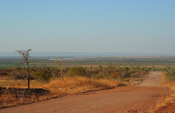
Heartbreak Trail:
Heartbreak Trail is a 10 km scenic unsealed one-way road (can be accessed by 2wd) through the Karri forest which snakes around the Dave Evans Bicentennial Tree (see climbing giant trees). From this road you can access Draftys camp site & Warren camp site.
There are other stops by the Warren River, which offer good opportunities for fishing and kayaking/paddling.
Some of these places of interest including the camp sites even have picnic huts, BBQs & toilet facilities.
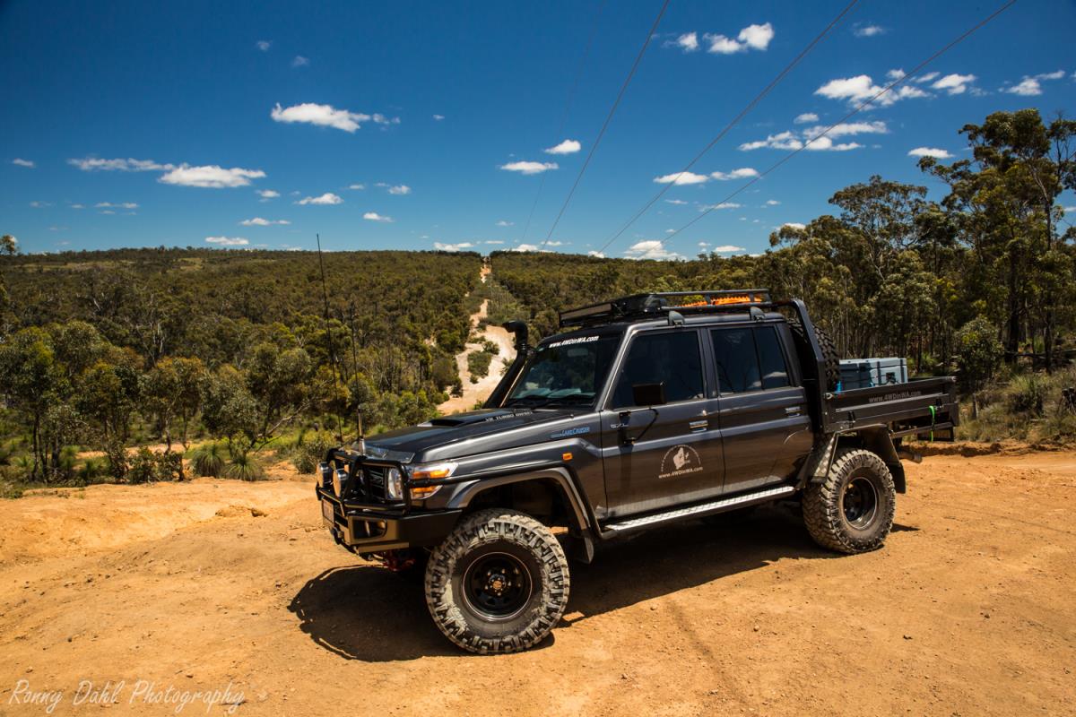
4WD only:
There are so many tracks in the Warren national park/state forest. If planning a trip there I would advise using Google earth and entering the GPS coordinates provided at the bottom of this page. I do this for every trip I do.
Planning a trip is half the fun, using the GPS waypoints you can almost guarantee to have a great trip as you will get to see or do the specific things & challenges you seek. It's common to have the odd tree (small or large) fallen across the track so having a hand/garden saw or chain saw will come in handy.
Heartbreak crossing:
There is a track which runs off the Heartbreak trail that will take you to a river crossing. This crossing can be very dangerous in winter if the water level is high as there are large rocks under the water. We have crossed this river in Jan (summer) while the water level was low.
At this visit there was a massive Karri tree which had fallen and was blocking the track, so we had to access the crossing from the other side going though bush tracks the very long way. I would hope that this tree is removed by some stage, as it would really open the area up. If crossing the river make sure you have a spotter.
And remember that all river crossing are at your own risk, even the concreted crossings. The signs before these crossing are very clear about this.
Moons Crossing:
A camp site by the river and this is first in first serve basis. It is also one of many river crossings in Warren State Forest.
All year round it's very easy to cross if you use the half concreted crossing, if you're up for a challenge you can attempt to cross the hard way by negotiating through the rocks and deeper water. This should not be attempted in winter by anyone, as most rocks are under water and the big drop offs are hidden, summer is ok if you know what you are doing and you have done rock crawling before. Make sure you have a spotter.
And remember that all river crossing are at your own risk, even the concreted crossings. The signs before these crossing are very clear about this.

River Crossing at Pemberton.
Barker road Crossing:
Is another camp site by the river and is first in first serve basis like most other camp sites in the national park.
There is also a river crossing that will cut travel time, this crossing is very easy and fun in summer, as it has a hill descent and an ascent at the other end, so which ever end you enter from its pretty much the same good fun. This crossing is a really good short cut as the only other way around is the long way on the black top, there is another track further south which avoids the river but last time we travelled there it was closed due to an unstable bridge or washed out road, so we actually found this Barker road crossing by chance.
Do take care in winter when water levels are high and as with all river crossings these are at your own risk.
Yeagarup Dunes:
The sand dunes are a part of D'Entrecasteaux National Park. The sand dunes here really tower over the landscape and you can see trees in the progress of being swallowed up by the dunes, as some are only just sticking out the top of the dunes. Yeagarup Dunes is very different compared to Lancelin dunes, as the sand at Yeagarup is slightly more yellow in colour and is surrounded by Karri forest to the north and the beach at the south.
The entry climb can be very challenging. It's a very step ascent with a 180 degree turn while you're trying to maintain momentum, we were there 2 days in a row, the first day we found it challenging, as only myself made it up the climb in one go, the rest of us had 2-5 attempts at it, however the next day when we visited the dunes again it was so easy to get to the top. It had rained overnight so the sand had compacted which made it very easy.
As you drive over the sand dunes there are markers indicating a path wide enough for 2 vehicles, you must stick between these markers if heading towards the beach.
You can leave the markers but make sure you keep a good distance away from them and take good care as there are steep drop offs on most of these dunes (see razorbacks) Once the sand dune formations have been crossed you will see a sand track which snakes through the bush land and will take you to a big dune decent.
See more at Yeagarup
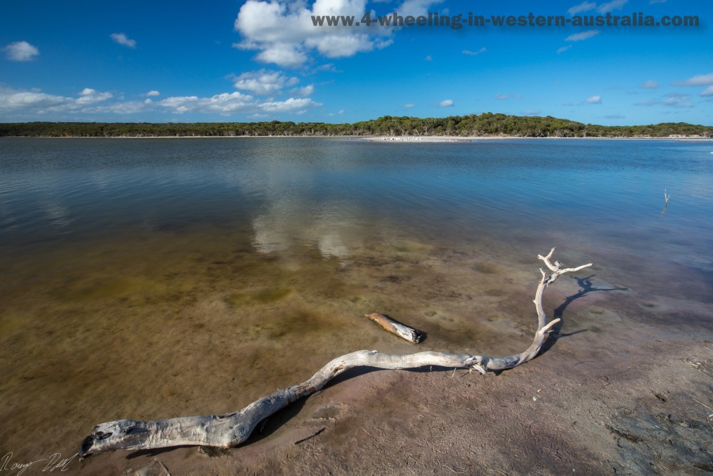
Warren River Mouth Crossing:
At the beach to the south east at the end of Yeagarup dunes, the Warren river flows out to the ocean (sometimes). This crossing I have not done, but many have.
This is where the river meets the ocean so timing with the waves is paramount (it helps to have surfed before as you would then know how to read the waves and sets), I would advise not to do this crossing if travelling by yourself/single vehicle, if you get stuck here by yourself, you may as well kiss your 4x4 goodbye.
At times this river is said to be unpassable, it could change overnight depending on the weather.
For more information go to Yeagarup
Track conditions and difficulty.
Easy - moderate
This description is pretty broad so here is a bit of a break down: Most forest tracks (this includes both national parks) are well maintained and you can tell as soon as you drive them.
The tracks that peel off can be overgrown, rutted, very muddy in winter & some submerged in deep water, it all really depends on the weather. Recommended PSI 20
The river crossings have their own descriptions (as above) Recommended PSI 20. The sand dunes are easy to medium, on a real soft day don't be surprised if you need to deflate right down to 10 PSI as there is a really long and high sand dune you need to get over in order to get back out.
The ranger station at the deflation area will have signs out with recommended PSI on the day, follow this and you should have no problem.
Things to do:
4WD Explore Warren National park/state forest & D'Entrecasteaux National Park.
4WD sand dunes
4WD River crossing
Sand boarding
Surfing
Hiking
Climbing Giant Trees
Fishing from rivers & beaches
Spend the day at the beach.
For the following visit the Pemberton visitor information centre for details:
Marron and Trout farms.
Enjoy some wineries and breweries.
Wine tours
What to bring:
Air
compressor, shovel, sunscreen, bush hat, good footwear, plenty of water, rated
recovery gear, hand/garden saw or chain saw, Surf board, fishing gear, Sun
shelter & Camera.
Best time to go:
All year round is great:
In summer it stays a bit cooler than Perth.
In winter you will get muddy tracks and other challengers.
Places to stay:
Camp grounds (see GPS waypoints for noted camp grounds):
Draftys camp grounds
Warren camp
grounds
Moons
Crossing
Baker
crossing
Caravan parks in Pemberton:
Pemberton Caravan Park, have stayed there before and it is a nice caravan park.
Cabins:

One of my favourite places is Karri Valley Resort (about 20km north of Pemberton) they have really nice cabins among the giant Karri trees and a lake full of Trout.
Just step outside the door and drop a line in the water and catch your dinner.
Or just enjoy the wildlife.
For more information see here.
Hotels in Pemberton:
Find the best deal in Pembelton here.GPS Waypoints:
|
For information about How to enter the GPS Way-points into Google Earth see this video. |
For information about How to enter the GPS Way-points into Google Earth
see this video.
General:
Start of Heartbreak Trail (Dave Evans Bicentennial Tree nearby):
|
Latitude: |
Longitude: |
Warren Camp grounds:
|
Latitude: |
Longitude: |
Drafty's camp grounds:
|
Latitude: |
Longitude: |
Gloucester National
Park and Gloucester Tree lookout:
|
Latitude: |
Longitude: |
Diamond Tree lookout:
|
Latitude: |
Longitude: |
River Crossings:
Moons Crossing:
|
Latitude: |
Longitude: |
Heart Breaks crossing:
|
Latitude: |
Longitude: |
Barker road Crossing:
|
Latitude: |
Longitude: |
Warren River Mouth
Crossing:
|
Latitude: |
Longitude: |
Yeagarup Dunes: Yeagarup dunes entry (deflate tyres here):
|
Latitude: |
Longitude: |
Start of Yeagarup Dunes:
|
Latitude: |
Longitude: |
Track to Beach:
|
Latitude: |
Longitude: |
You might like these
resources
resources for 4-wheeling-in-western-australia.com/
Historic Tracks in Australia by 4 Wheel Drive.
Historic Tracks in Australia by 4WD, is Gibb River Road, Canning Stock Route or other historic tracks on your bucket list...
GPS Waypoints for Bremer Bay Area.
Bremer Bay Area GPS waypoints, Point Henry, beaches close to Bremer Bay and mo.....

Recent Articles
-
4x4 off road tracks 0 to 250 km from Perth
Nov 21, 23 07:40 PM
 On this page we cover 4x4 off road tracks within a 250 km radius from Perth...
 -
4 Wheeling Around Jurien Bay.
Nov 21, 23 07:35 PM
 Jurien Bay 4x4 tracks info and general information about the area...
 -
Carnamah caravan Park WA
Oct 10, 23 09:31 PM
This caravan park is very clean. The ablutions are spotless. The washing machines are free but need to keep them clean. Easy parking for big rigs and if
- Home
- 250-500km From Perth
- Pemberton
Leave Pemberton And Go To 4 Wheeling In Western Australia.


Privacy Policy | Disclaimer | Contact Us
By Brian Dahl, Copyright© 2012- All Rights Reserved