Mundaring Weir and state forest.
Distance
from Perth: 40km
Nearest Fuel: Sawyers Valley
Size: 130000 hectares of state forest

Mundaring Weir is a dam which contains the Helena River Reservoir.
To prevent contamination, access to the reservoir is restricted as it serves as drinking water for the goldfield.
The dam itself is a tourist attraction and access to the top of the dam is allowed.
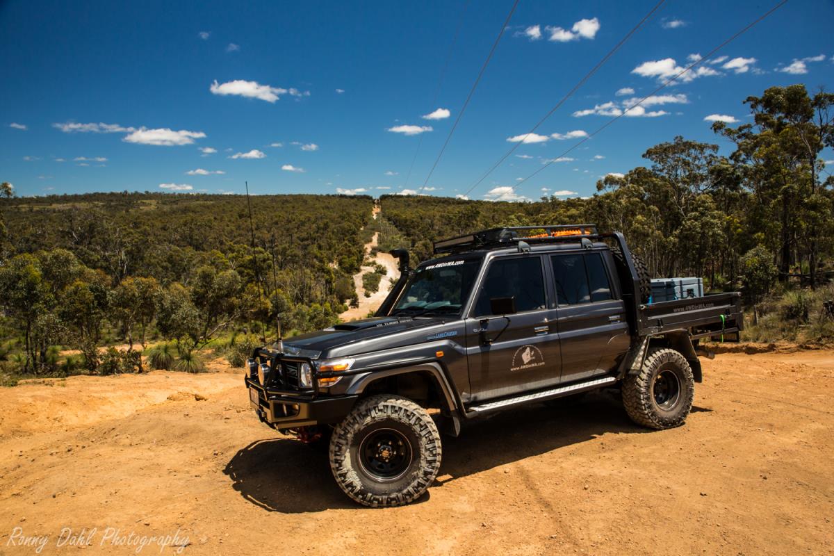
There is plenty to see and do in Mundaring state forest, it's not all about the well-known Powerline track (click here for Powerline track) which runs parallel to Great Eastern hwy at the northern part of the Mundaring forest.
There are gravel roads and easy tracks to a few medium tracks/trails and hill climbs. It's a perfect area for a nice day trip with the family or a trip with the boys including a few fire break tracks and some hill climbs.
Mundaring Weir and state forest has lookouts, rocky outcrops small and large, small cascades/waterfalls and an abundance of wild life. Kids are almost guaranteed to see kangaroos, emus, reptiles and plenty of native birds when visiting Mundaring Weir and the state forest.
There is no real must start entry point or particular must travel tracks to take as we have entered from 4+ different points which are all great and most tracks will zig zag the way through to the main or secondary gravel roads.
Among the GPS way point below we will include all multiple entry points that are guaranteed to be open. We suggest using Google earth with the waypoints below to plan your journey, without rushing there is enough places listed below for 3 trips, maybe more and countless days for further exploring.
Lookouts:
Mt Dale lookout:

View From Mt Dale lookout at Mundaring Weir.
Mt
Dale is one of the better look outs at Mundaring Weir, from the very top Perth CBD
towers can be seen in the distance along with the vastness of state forest. On
a sunny day the view is clear for miles and on a cold winters morning its looks
mystical while covered in fog.
Before the tip of Mt Dale there are picnic tables and toilets, however if feeling
like a bite to eat I would recommend setting up a few deck chairs at the
lookout instead.
See GPS waypoint below for location.
Mt Observation lookout:
This lookout is more of a picnic/lunch stop than a lookout as the amount of trees block most of the limited view there is, however it's still a nice place for a quick stop or bite to eat.
Best in summer as the trees provide plenty of shade.
See GPS waypoint below for location.
Mundaring Weir lookout (top of dam wall):
From the top of the lookout/dam wall there is a good view of Lake C.Y. O'Connor and the old pump station. The lake supply's water to the Goldfields via a 530 km long pipeline between Perth and Kalgoorlie also known as the Goldfields Pipeline.
Rocky Outcrops:
These are always more spectacular in winter as the blue rocky outcrops are partially covered with bright green moss.
There are so many in the Mundaring state forest, and every time we visit we always find another large one.
After heavy
rain some rocky outcrops become small cascades and water falls.
To list a few of the better rocky outcrops:
Nockine Rock:

Nockine Rock Mundaring Weir.
This rock formation is right on an actual intersection of tracks.
In winter Nockine rock is very mystical and worth seeing.
A small stream flows across the lower
part into a pool of water during winter and with all the bright green moss on
the blue rock formations it makes a great photo opportunity.
Nockine rock is well worth spending a bit of time at and the kids will love it too.
Just a little bit further west (about 200-400 meters) from Nockine Rock is another outcrop which is joined by the water stream.
See GPS waypoint below for location.
Observation Rock:

Observation Rock at Mundaring Weir.
This particular rocky outcrop is unnamed to my knowledge so I will just call it Observation Rock as it’s just a bit south of Mt Observation.
The rock itself is to be driven up onto and parked on (make sure the hand brake works).
When on the rock it will become clear that it's a bit of a lookout as well
(better than Mt Observation lookout) and it’s a great spot for a short stop or
a bite to eat.
See GPS waypoint below for location.
Small waterfalls and cascades at Mundaring Weir.
In Mundaring state forest there are a few small waterfalls and cascades scattered around. Stay tuned for more information on these in future.
Tracks and Fire breaks:
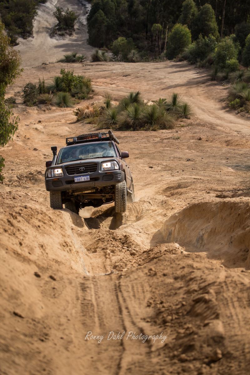
Most tracks in the Mundaring state forest are easy and very tame but there are a few fun and challenging sections along the way.
It's better in winter as quite a few sections turn into mud runs, water filled ruts, water holes and shortly after a bit of winter rain the wash outs make for interesting driving.
On fire breaks there are always some challenging sections unless recently levelled by earth movers, which can happen after big storms as the fire authorities need to access the thunder struck trees. Otherwise the fire breaks are untouched and very fun in parts.
Main stretches of fire breaks are at the eastern end of the
state forest.
See GPS waypoint below for locations in regards to tracks & fire breaks.
Track conditions and difficulty:

Muddy 4x4 Track at Mundaring Weir.
The tracks consist of mainly clay, dirt and gravel.
Most tracks are easy and if encountering a difficult area there will always be another way around it, whether it's a chicken track or another track completely. Expect to find a few trees across the less travelled tracks.
You will require low range gear for some parts of the track. If chasing challenges all day then there is a good chance here low range gears are required for most of your adventures.
Recommended PSI is 22 or lower if climbing steep hills.
All terrain tires are great for this track and mud terrains are even better, especially in winter.
What to bring:
Air compressor
Shovel
Rated recovery gear
Sunscreen
Bush hat
Plenty of water
Camera
Lunch.
Things to do:
See the sites
Explore the bush
Photography
Enjoy hill climbs
Muddy day out in winter
Best time to go:
All year round. Keep in mind it does get very hot in the hills during summer.
GPS Waypoints:
|
For information about How to enter the GPS Way-points into Google Earth see this video. |
For information about How to enter the GPS Way-points into Google Earth
see this video.
Sawyers Valley Tavern: A good meeting place.
|
Latitude: 31°54'13.76"S |
Longitude: 116°12'16.30"E |
The multiple entry points:
Entry point- power line track. please note this is NOT “The Hardcore Mundaring Powerline Track” but another powerline track in Mundaring stretching from north to south (very slow and rugged with small parts of the track are similar to the hardcore powerline track):
|
Latitude: 31°58'22.83"S |
Longitude: 116° 6'2.15"E |
Entry point-: Corner of Great Southern HWY & West Talbot Rd (this is the entry road to the end/reverse start of the “The Hardcore Mundaring Powerline Track”)
|
Latitude: 31°52'38.47"S |
Longitude: 116°25'33.12"E |
Entry point-: Corner of Great Southern HWY & Yarra Rd (this is a fast track to the centre of the state forest)
|
Latitude: 31°52'55.81"S |
Longitude: 116°27'21.36"E |
Entry point-: Instant Off road entry track (good for muddy sections in the winter/wet)
|
Latitude: 31°52'56.22"S |
Longitude: 116°30'33.21"E |
Observation Rock:
|
Latitude: 31°58'7.68"S |
Longitude: 116°35'27.72"E |
Lookout way points:
Mt Dale lookout:
|
Latitude: 32° 7'34.29"S |
Longitude: 116°17'57.70"E |
Mt Observation lookout:
|
Latitude: 31°53'47.43"S |
Longitude: 116°33'26.04"E |
Mundaring Weir lookout:
|
Latitude: 31°57'24.14"S |
Longitude: 116° 9'54.07"E |
Other waypoints:
Hill Climbs: (a few good ones going up through pine plantation tracks in this area. They are not extreme and are good for less experienced 4 wheel drivers)
|
Latitude: 32° 4'47.69"S |
Longitude: 116°18'20.87"E |
Start of Fire break track, follow as far as desired: (not extreme or hard but still fun in the wet).
|
Latitude: 31°54'6.10"S |
Longitude: 116°34'27.05"E |
You might like these
4x4 off road tracks 0 to 250 km from Perth
On this page we cover 4x4 off road tracks within a 250 km radius from Perth...
4 Wheeling Around Jurien Bay.
Jurien Bay 4x4 tracks info and general information about the area...
Mundaring power line track
At Mundaring you can enjoy an action packed day 4wheel driving

Recent Articles
-
4x4 off road tracks 0 to 250 km from Perth
Nov 21, 23 07:40 PM
 On this page we cover 4x4 off road tracks within a 250 km radius from Perth...
 -
4 Wheeling Around Jurien Bay.
Nov 21, 23 07:35 PM
 Jurien Bay 4x4 tracks info and general information about the area...
 -
Carnamah caravan Park WA
Oct 10, 23 09:31 PM
This caravan park is very clean. The ablutions are spotless. The washing machines are free but need to keep them clean. Easy parking for big rigs and if
- Home
- 0-250 From Perth
- Mundaring Weir
Leave Mundaring Weir And Go To 4 Wheeling In Western Australia.


Privacy Policy | Disclaimer | Contact Us
By Brian Dahl, Copyright© 2012- All Rights Reserved